The sequence of events that resulted in the breach of the New Orleans levees, and how those breaches related to Karina itself, has puzzled me ever since my brother pointed out that the breaches appeared to have occured after the worst of the winds (and therefore, presumably, the worst of the strom surge) had passed. I have not fully figured it out yet, and I expect that it will be months if not years before all of the gory details are available. But I did finally find an article on that exact subject by John MacQuaid of the New House News Service entitled Anatomy of a Disaster.
The entire article is reprinted below. However, when I first read it, I had some trouble with the geography it describes, so I have added a couple of maps that helped sort that part out.
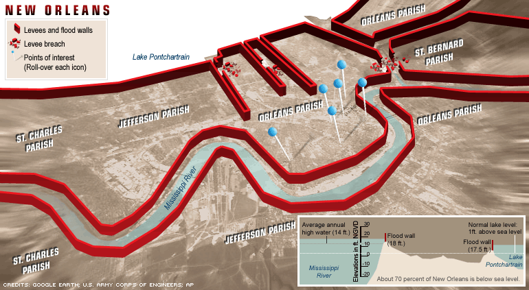
The first of these is a very simple map from CNN showing the levee system and points of collapse :
(BTW: CNN also has by far the best set of satellite images I have seen so far. Well worth exploring).
Two other useful maps are linked below:
From the NYT: a whole series of maps showing more info on elevantions, Parish/Ward names, areas of flodding, etc., etc. For present purposes the most useful of those maps is the "Elevation Information" map under the "In New Orleans" tab at the top of the page)
From Google maps: an interacitve map of the entire area (linked with satlellite images) that you can zoom in and out and scroll up/down/right/left to get a good overview of the entire area.
One final note: Hurricanes rotate counterclockwise. Thus, as the eye of Katrina passed east of New Orleans, the winds initially came from the east and then gradullay shifted in a counterclockwise direction: coming from the east, then northeast, then the north, then the northwest, then, finally, the west. In a storm that moves north onto an east-west coast, as Katrina did, the worst of the storm surge generally occurs in the northwest quadrant of the storm, since this is the quadrant that is blowing seawater directly at the coast. This the reason the Gulfport/Biloxi area was so devastated. It is also the reason why initial reactions were that New Orleans itself had "dodged a bullet." It did dodge one bullet, since the last-minute northeasterly turn of the storm meant that Mississippi, rather than New Orleans took the brunt of the initial northerly surge of the Gulf waters. But New Orleans' peculiar geography meant that there were a couple bullets yet to come, since New Orleans also has signifianct bodies or water on its eastern side (Lakes Borgne and the Mississippi Sound -- see the Google Map linked above) and, more importantly, to the north (Lake Pontchartrain).
With the geopgraphy lesson complete, here's McQuaid's Article:
Hurricane Katrina dealt a devastating double blow to the New Orleans area on Monday, Aug. 29. First, storm surge waters from the east rapidly swamped suburban St. Bernard Parish and eastern New Orleans before the eye of the storm had passed the city around 9 a.m. Within hours, surge waters collapsed city canal floodwalls and began to "fill the bowl," while top officials continued to believe for another day that the danger had passed.
A rough reconstruction of the flooding, based on anecdotal accounts, interviews and computer modeling, shows that the huge scale of the overlapping floods -- one fast, one slow -- should have been clear to some officials by midafternoon that Monday when city officials confirmed the 17th Street Canal floodwall had been breached, say experts familiar with the city's extreme flood risks.
At that point areas to the east were submerged from the earlier flooding, trapping thousands, and low, gradually rising waters stretched from the Lakefront area near the breach across the city's center.
Federal officials have referred to the levee breaches as a separate and much later event from the flooding to the east, and said that they were unaware of the gravity of the problem until Tuesday, Aug. 30, suggesting valuable response time was lost.
"It was midday Tuesday that I became aware of the fact that there was no possibility of plugging the gap and that essentially the lake was going to start to drain into the city. I think that second catastrophe really caught everybody by surprise," Homeland Security Secretary Michael Chertoff said Sunday, adding that he believed the breaches had occurred that Monday night or Tuesday morning. But flooding from at least one and probably both of the two breached canals was under way all day that Monday.
Even that Tuesday, as still-rising waters covered most of New Orleans, FEMA official Bill Lokey sounded a reassuring note in a Baton Rouge, La., briefing.
"I don't want to alarm everybody that, you know, New Orleans is filling up like a bowl," Lokey said. "That's just not happening."
Once a levee or floodwall is breached by a hurricane storm surge, engineers say, it often widens and cannot be quickly sealed. Storm surges push waters in Lake Pontchartrain well above sea level and they may take a day or more to subside. So they keep pouring into the city -- most of which lies below sea level -- until the levels inside and outside the levee are equal.
Experts familiar with the hurricane risks in the New Orleans area said they were stunned that no one had conveyed the information about the breaches or grave risk they posed to upper-level officials, or made an effort to warn residents after winds subsided that Monday afternoon.
"I'm shocked. I don't understand why the response wasn't instantaneous," said Louisiana State University geology professor Greg Stone, who studies coastal storm surge dynamics.
"They should have been monitoring this and informed people all the way to the top, then they should have warned people," said Ivor Van Heerden, who models storm surges at the LSU Hurricane Center and provided officials in the Louisiana Office of Emergency Preparedness headquarters with models indicating the potential for flooding that could result from Katrina.
As Katrina approached the coast early that Monday, the easterly winds from its northern quadrant pumped a rising storm surge from the Gulf of Mexico into a marshy area due east of the city. There, two hurricane levees come together into a large V-shape. Storm surge modelers say that point acts as a giant funnel: Water pouring into the confined area rises up -- perhaps as much as 20 feet in this case -- and is funneled between the levees all the way into New Orleans.
The water likely overtopped the levee along the north side adjacent to eastern New Orleans, according to Army Corps of Engineers New Orleans project manager Al Naomi.
The surge poured into the Industrial Canal running through New Orleans before dawn and quickly overflowed it on both sides, the canal lockmaster reported to the corps. At some point not long afterward, corps officials believe a barge broke loose and crashed through the floodwall, opening a breach that accelerated flooding into New Orleans' Lower Ninth Ward and St. Bernard Parish.
The floodwaters moved quickly.
By around 8 a.m., authorities reported rising water on both sides of the Industrial Canal in New Orleans, in St. Bernard and in eastern New Orleans. The Coast Guard reported sighting residents on rooftops in the Upper Ninth Ward.
At 9 a.m., there was six to eight feet of water in the Lower Ninth Ward, state officials said. Less than two hours later, most of St. Bernard was a lake 10 feet deep. "We know people were up in the attics hollering for help," state Sen. Walter Boasso said that morning.
Sometime that Monday morning, the 17th Street Canal levee burst when storm surge waters pressed against it and possibly overtopped it, corps officials say.
Naomi said he believed the breach occurred mid- or late-morning after Katrina's eye had passed east of the city. By that time, north winds would have pushed storm surge water in Lake Pontchartrain south against the hurricane levees and into the canals, which normally drain water from the city into the lake.
Then the wind shifted to the west.
"As I remember it the worst of the storm had passed when we got word the floodwall had collapsed," Naomi said. "It could have been when we were experiencing westerly winds in the aftermath of the storm, which would have been pushing water against it."
Naomi and other corps officials say they believe that the water in the canal overtopped the levee on the Orleans Parish side, weakening its structure on the interior side and precipitating its collapse. However, Van Heerden said he does not believe the water was high enough in the lake to top the 14-foot wall and that instead the pressure caused a "catastrophic structural failure."
It's not clear when floodwalls in the London Avenue canal were breached, but Naomi said it may have been around the same time.
Once the floodwalls failed, water -- then at about eight feet or higher in the lake -- began to pour into New Orleans from the west, beginning the full-scale nightmare emergency managers and other officials most feared.
Naomi said that he believed corps officials had communicated the information about the breaches to the Baton Rouge Office of Emergency Preparedness
"It was disseminated. It went to our OEP in Baton Rouge, to the state, FEMA, the corps," Naomi said. "The people in the field knew it. The people here (in corps offices) in Louisiana and Mississippi knew it. I don't know how communication worked in those agencies."
Officials at the OEP and the Federal Emergency Management Agency could not be reached for comment. New Orleans officials were also aware of the 17th Street Canal breach and publicly confirmed it at 2 p.m. that Monday.
As the day wore on, the flood from the breaches made its way across the city, penetrating neighborhood after neighborhood.
As night fell that Monday, many outside New Orleans breathed a sigh of relief believing the city had been largely spared the worst.
But thousands were stranded on rooftops. And waters continued to rise overnight throughout central New Orleans from the breaches. By dawn, the flood stretched all the way from east to west and south into the city's crescent-shaped Uptown neighborhoods, and was coursing through the Central Business District. As TV helicopters flew over the city and beamed out pictures of the flooding, the extent of the catastrophe was clear. For most, help was days away.
Sept. 8, 2005
(John McQuaid can be contacted at john.mcquaid@newhouse.com)
No comments:
Post a Comment